Innovative Insights Into Coral Substrate and Rugosity
Corals are essential to our ecosystems, and our job is to protect these endangered animals. Since the creation of Innoceana, much of our research has focused on finding new ways to monitor coral reefs and collect data. We hope to introduce new government policies in Costa Rica and protect our natural spaces.
Our research project is a two-part study: measuring coral rugosity and the coral substrate layer.

WHAT IS CORAL RUGOSITY?
Rugosity is a term used by coral reef biologists to measure the surface roughness of a coral reef. It is also an indicator of coral biodiversity and the disturbances they endure. Research studies have shown that reefs with a high level of rugosity have a better abundance of marine life and species. Importantly, areas with high rugosity have more surface area for corals to attach and grow.
OLD METOD
Coral rugosity data was collected using the Line Intercept Transect by laying a steel chain on the reef’s surface. Scientists determined the rugosity values by comparing the path distance to the direct linear distance. They then averaged it out for the reef plot surveyed. However, this method provided not only poor results (the scale captured was too small to analyze correctly), but also was invasive and destructive to the coral reefs studied.


NEW METOD
Over the years, we applied a new research method to test coral rugosity. Indeed, the Structure from Motion (SfM) allows a better understanding of coral reef rugosity, because it can virtually measure the rugosity profile along any segment of the surveyed area.
The SfM method, used more and more by marine scientists today, proves non-destructive and more accurate. The data collected demonstrates the impact of research projects or ongoing environmental crisis, is less biased by the observer, and has a broader range of applications than standard methods. This work allows researchers to transition from analog to digital structural assessment techniques, so they can keep monitoring the situation long-term, while also improving the quality and value of the collected data for research.
HOW DOES THE RESEARCH TAKE PLACE?
When our scientists dive, they set up 10×10 meters of transect lines underwater. Inside these lines, they take photos back and forth in one way and then the other. The most important part of this fieldwork is to ensure that the photographs overlap. This SfM technique is applied to create the coral mapping.
Afterward, using the Agisoft Metashape software, our scientists put all overlapping imagery data together, creating a 3-Dimensional (3D) modeling of our coral reef ecosystems. Then using the Gwyddion Program, we can calculate the level of rugosity in corals.
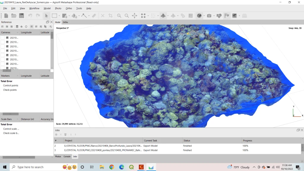
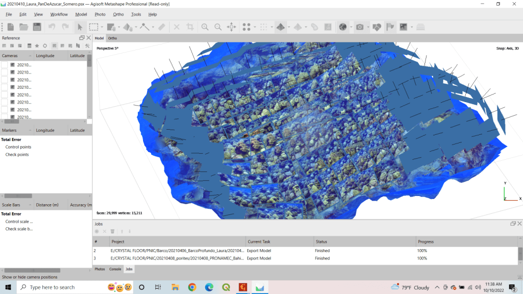
(AGISOFT - part 1 - pictures that have been put together then part 2 on the right - then making the 3D model)
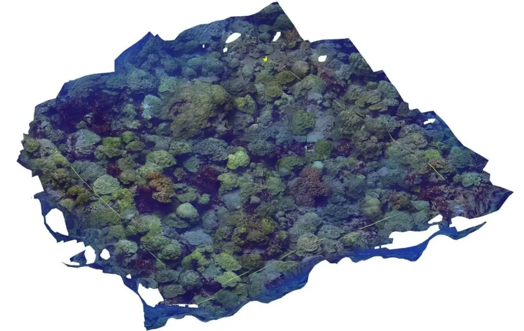
(part 3 - a 2D model based on the 3D one)
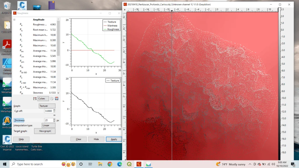
(Using the Gwyddion Program, we analyze the coral rugosity from the Data collected from the Agisoft program)
3D MODELING
The 3D approach can better quantify rugosity characters essential to preserve coral reef communities. Future research integrating 3D reconstructions of reef structure with other physiological and ecological parameters can develop reliable ecosystem models and improve our ability to monitor coral reef ecosystem health and function changes.

WHY RESEARCH RUGOSITY?
High rugosity is essential, as it creates a healthy habitat for marine species and resources. It is strongly linked to the quality, salinity, and temperature of the water, as the latter directly impacts coral rugosity and corals in general. It is crucial to measure coral rugosity annually to determine if the rugosity declines throughout the year due to the ongoing climate crisis. Our research will be used to provide data to protect better coral rugosity in our local ecosystems. Indeed, the study, results, and analysis will give the Costa Rican Government data to implement better coral reef rugosity methodologies. This research has been carried out in Cocos Island in Costa Rica.
Measuring the coral substrate layer
To monitor the health of coral reefs in Costa Rica, our scientists measure the coral substrate layer. There are different categories of substrate levels, from living coral, dead coral (skeleton), coarse or fine sand… Categorizing the corals determines the level of stress (whitening) the corals are under.
The two main variables determining the geomorphology or shape of coral reefs are the nature of the substrate on which they lie, and the history of sea level changes relative to that substrate. This measurement provides us with information and data about the physical conditions of the corals studied. This is to maintain their safeguarding over the years, or in other cases, to develop policies to increase their protection or rehabilitation.
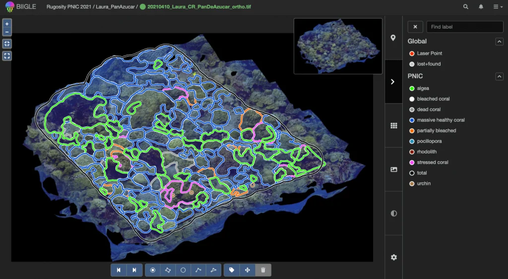
Using the BIIGLE software, we can create seabed maps that can be archived and analyzed throughout the years. Biigle is a software designed to annotate images and videos for surveillance and exploration. We can closely examine the coral substrate layer and create statistics on the health of corals to determine the stress level the corals face, whether they are in good health or not.
The first year our scientists, Laura and Carlos, studied the coral substrate layer was in 2021 in the protected area of Cocos Island. Currently, two of our marine biologists, Laura and Julia, are returning to the island to investigate the coral substrate layer again. These new results will enable us to evaluate the data received in 2021 and 2022. Comparing the different data will show if there has been an improvement or deterioration on the corals’ health.
